This project was developed as part of my tenure at the Massachusetts Institute of Technology’s Senseable City Lab where I led an interdisciplinary research team comprising computer scientists, architects, planners, and designers both in Boston and Singapore.
With the increasing deployment of digital technologies throughout transportation infrastructures, data generated from their operations can help provide valuable insights into urban mobility and a city’s overall dynamics. Technologies in place in Singapore specifically include public transport smart cards, electronic road pricing gantries, car-counting loop detectors, etc.
As part of the LIVE Singapore! initiative and in collaboration with Singapore’s Land Transport Authority we have developed a number of interactive visual applications to explore the wealth of information concealed in some of the mobility data generated throughout the island. By making this complex data accessible in visual and interactive ways, experts and citizens alike can gain a better understanding on the underlying dynamics of urban mobility in their city. By enabling people from various backgrounds to jointly interact with this data, the project supports the interdisciplinary discourse in developing new services and functionalities that can effectively support future modes of mobility.
Touching Bus Rides
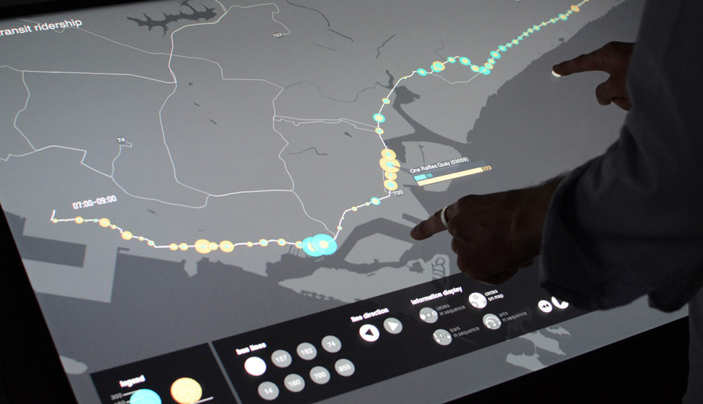
Motivated by the public transport system’s distance-based fare prices, travelers in Singapore tap their smart card passes both when boarding and alighting subways and buses. The data generated in this way thus contains detailed information about the number of passengers entering and exiting means of transport at any given time and station and also offers an understanding on the number of passengers aboard of vehicles at any given time.
We developed this interactive application for a large scale multi-touch interface so that users can actively engage with the data and explore the city’s public transport network. Users can see for themselves at any given time and location where most passengers get on and off buses, how people connect between the island’s stations, and see how these patterns vary over time.
Please find further information on the MIT project page.
Team
Kristian Kloeckl, project leader
Afian Anwar
Rohit Bhatnagar
Pedro Cruz
Nic Marchesi
Till Nagel
Oliver Senn
Carlo Ratti, director
Assaf Biderman, associate director
In collaboration with
Singapore Land Transport Authority (LTA)
This project was developed as part of my tenure at the Massachusetts Institute of Technology’s Senseable City Lab where I led an interdisciplinary research team comprising computer scientists, architects, planners, and designers both in Boston and Singapore.
With the increasing deployment of digital technologies throughout transportation infrastructures, data generated from their operations can help provide valuable insights into urban mobility and a city’s overall dynamics. Technologies in place in Singapore specifically include public transport smart cards, electronic road pricing gantries, car-counting loop detectors, etc.
As part of the LIVE Singapore! initiative and in collaboration with Singapore’s Land Transport Authority we have developed a number of interactive visual applications to explore the wealth of information concealed in some of the mobility data generated throughout the island. By making this complex data accessible in visual and interactive ways, experts and citizens alike can gain a better understanding on the underlying dynamics of urban mobility in their city. By enabling people from various backgrounds to jointly interact with this data, the project supports the interdisciplinary discourse in developing new services and functionalities that can effectively support future modes of mobility.
Touching Bus Rides
Motivated by the public transport system’s distance-based fare prices, travelers in Singapore tap their smart card passes both when boarding and alighting subways and buses. The data generated in this way thus contains detailed information about the number of passengers entering and exiting means of transport at any given time and station and also offers an understanding on the number of passengers aboard of vehicles at any given time.
We developed this interactive application for a large scale multi-touch interface so that users can actively engage with the data and explore the city’s public transport network. Users can see for themselves at any given time and location where most passengers get on and off buses, how people connect between the island’s stations, and see how these patterns vary over time.
Please find further information on the MIT project page.
Team
Kristian Kloeckl, project leader
Afian Anwar
Rohit Bhatnagar
Pedro Cruz
Nic Marchesi
Till Nagel
Oliver Senn
Carlo Ratti, director
Assaf Biderman, associate director
In collaboration with
Singapore Land Transport Authority (LTA)